Pits Atlas: King 1b
| Impact Melt pit: King | |
|---|---|
| Name | King 1b |
| Lat. | 6.2402 |
| Long. | 119.7351 |
| Desc. | Elliptical pit, southeastern of a pair "separated" by a bridge. Floor slopes from ~2m below E rim to ~5m lower below the S end of the bridge. There is a cluster of 1-5m boulders under the E side of the bridge (there's a 5m-long block directly under the NE edge). No driving access, except by going under the bridge. |
| Types | |
| Terrain | Impact Melt |
| Host Feature | King |
| Funnel Min. Diam. | 21 |
| Funnel Max. Diam. | 32 |
| Inner Min. Diam. | 18 |
| Inner Max. Diam. | 28 |
| Azimuth | 120 |
| Depth | 10.0 |
| Depth 1 | 12.1 |
| Depth 2 | 7.6 |
| Depth 3 | 11.6 |
| Best Stereo Left | M143839277L |
| Best Stereo Right | M143839277L |
| DTMs | NAC_DTM_KINGCRATER3 |
| Clipping Width | 200 |
| Other IMGs | |
| Data Warning | Depth 2 is from rim, other depths are from bridge. |
| Entrance Ramp | N |
| Overhang | Y |
| Nearby Pits? | Y |
| Nearby Fractures? | Y |
| Nearby Depressions? | Y |
| In Dome | Y |
| Beside Dome | Y |
| In Depression | N |
| Colinear Pits | N |
| Colinear Depressions | N |
| Colinear Fractures | N |
| King 1b Shaded Relief | |
|---|---|
 |
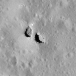
| M106088433L | |
|---|---|
 |
|
| Line | 41351 |
| Sample | 2891 |
| Inc. Angle | -35.08 |
| Emission Angle | 1.56 |
| Time | 14.29 |
| Resolution | 1.29 |
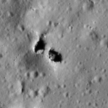
| M1153439131L | |
|---|---|
 |
|
| Inc. Angle | 58.51 |
| Emission Angle | -1.34 |
| Time | 8.12 |
| Resolution | 1.28 |
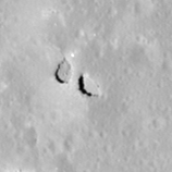
| M185104801R | |
|---|---|
 |
|
| Inc. Angle | -20.75 |
| Emission Angle | -0.46 |
| Time | 13.35 |
| Resolution | 1.26 |
| King 1b Stereo |
|---|
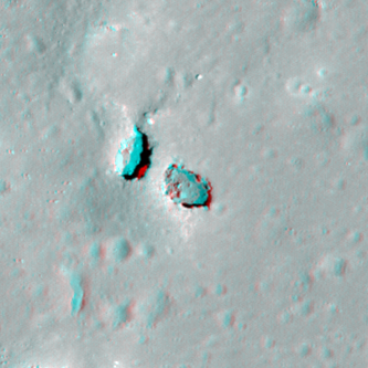 |